Kabah: History and Major Facts of this Maya Archaeological Site
Kabah is a Maya archaeological site in the Puuc region of western Yucatán, south of Mérida, known for its grand architecture and cultural significance. Below, WHE delves into the history and major facts of the unique ancient archaeological site.

Map showing the archeological zone of Kabah.
Summary
Kabah, also spelled Kabaah, Kabáh, Kahbah, or Kaba, is a significant Maya archaeological site located in the Puuc region of western Yucatán, Mexico. This ancient city lies south of Mérida and forms part of a cluster of important Maya sites, including Uxmal, Sayil, and Labna. These sites, known for their distinctive Puuc architecture, were collectively recognized as a UNESCO World Heritage Site in 1996 due to their cultural and historical importance. Among them, Kabah stands out as the second-largest archaeological site in the Puuc area after Uxmal.
Situated along Federal Highway 261, Kabah is approximately 140 kilometers south of Mérida on the route to Campeche. Its accessible location has made it a favored destination among tourists exploring the archaeological richness of the Yucatán Peninsula. Notably, Kabah is connected to Uxmal by a raised ceremonial causeway, a sacbe, which stretches for 18 kilometers and is five meters wide, featuring monumental arches at both ends. This architectural marvel underlines the importance of Kabah in ancient Maya society and its strong link to neighboring urban centers.
Historical Background
The name Kabah was introduced in the mid-19th century by Estanislao Carrillo and is thought to derive from the ancient Maya term meaning “strong hand.” It is believed that this was the site’s original pre-Columbian name, as referenced in the Book of Chilam Balam of Chumayel. An alternative interpretation proposed by Teoberto Maler is “Kabahaucan,” which translates to “royal snake in the hand.”
Archaeological evidence indicates that Kabah was first inhabited around the mid-3rd century BCE. The city reached its zenith during the Late Classic period, roughly between the 7th and 11th centuries CE. A notable date inscribed on a sculpted doorjamb from Structure 2C6 points to the year 879 CE, which scholars believe corresponds to the height of the city’s prosperity. Another inscription from 987 CE is among the latest known dates in the Maya Classic style, signaling the enduring cultural activity at Kabah even as the Classic period drew to a close.
Kabah gained state protection in 1993 when it was declared a Yucatán state park. Ongoing restoration and excavation efforts, led in part by archaeologist Ramón Carrasco, have brought renewed attention to the site’s extensive architecture and artwork.
Architectural Highlights
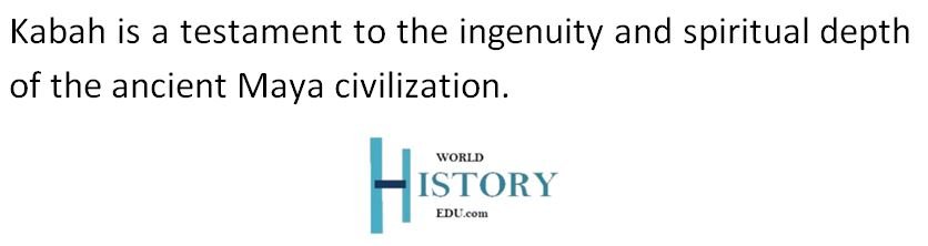
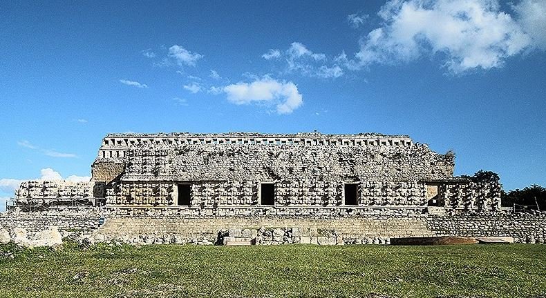
The most iconic structure at Kabah is the Palace of the Masks, also known by its Maya name, Codz Poop, meaning “Rolled Matting.” The facade of this building is decorated with over 250 masks of the rain god Chaac, making it one of the most visually striking monuments in the Maya world. The repetition of Chaac’s long-nosed visage is unique and symbolically significant, highlighting the vital role that rainfall and water played in this region where natural water sources like cenotes are scarce.
Throughout Kabah, the imagery of Chaac recurs frequently, not only in the Codz Poop but also across other temples and palaces. This consistent focus on the rain god reflects the environmental realities of the Puuc region, where the absence of rivers and cenotes made rain the only reliable source of water. Copal incense offerings have been discovered within some of the stone noses of the masks, suggesting that religious rituals were conducted to appease the rain deity.
Beyond the Palace of the Masks, the site includes a number of other palaces, temples, step pyramids, and low stone buildings. Most of these structures follow the Puuc architectural style, known for its smooth lower walls and intricate stone mosaics on the upper sections. However, some buildings at Kabah incorporate Chenes-style elements, characterized by elaborate monster-mouth doorways and ornamental facades. Many original sculpted panels and carvings depicting rulers and scenes of warfare have been removed and preserved in museums.
The city’s strong association with the rain god Chaac underscores the environmental challenges faced by its inhabitants and their spiritual responses to those challenges.
The Northwest Group
This group consists primarily of Structures 1A1 and 1A2, located on a hilltop that overlooks the main portion of the city. These structures are supported by several smaller ancillary buildings and occupy a strategic position at the western boundary of Kabah. From this elevated vantage point, the group directly faces the central pyramid temple known as Structure 1B2, emphasizing its ceremonial or administrative significance.
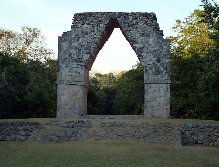
A close view of the Arch of Kabah
The West Group
The West Group encompasses Structures 1A7 and 1A8 along with the Court of Structures 2A1, which includes Structures 2A1, 2A2, and 2A3. This area forms part of the western fringe of the site and contributes to the broader urban layout that characterizes Kabah’s architectural planning.
The East or Palace Group
The East Group, often referred to as the Palace Group, is the largest and most architecturally significant section of Kabah. It includes Structures 2B1 through 2B3, 2C1, 2C4, 2C5, and most notably, the Codz Poop (Structure 2C6) and Structures 2C2, 2C3, and 2C7. These well-preserved buildings are arranged to face westward, overlooking the central area of the city and the Northwestern and Western groups across the landscape. The orientation and monumental design of these structures suggest their prominence in the civic and ceremonial life of Kabah.
Other Peripheral Groups
In addition to the central core, Kabah includes numerous architectural groups situated further afield. These structures include 1A3 through 1A6, 1B2 and 1B3, 1C1 through 1C3, and 3B1. Some of these groups likely served residential, administrative, or ritual functions and provide a more complete picture of Kabah’s urban complexity.
Sculptures and Monuments
Kabah is home to several intriguing sculptures identified as M1 through M7. These fragments are thought to be remnants of statues representing rulers or possibly deities. Among them, M1 is particularly significant, as it appears to be a clenched hand. This sculpture may have inspired the site’s name, “Kabah,” referring to a “strong hand.” In addition to freestanding sculptures, Kabah also contained numerous carved altars, doorjambs, and lintels, many of which have been relocated for preservation.
Despite the relocation of many original artifacts, Kabah still retains more large-scale monumental architecture than any other site in the Puuc region. This speaks to the city’s former grandeur and the sophistication of its builders.
Read More: Maya City of Calakmul: History and Major Facts
Research and Excavation
The earliest detailed study of Kabah was conducted by the explorer John Lloyd Stephens and illustrator Frederick Catherwood in 1843. Their documentation laid the groundwork for later research, which has expanded significantly over the years. A notable expedition in 1955, led by Karl Ruppert and A. Ledyard Smith, focused on identifying and comparing residential structures in the region around Mayapan. Their study revealed that houses at Kabah tended to be single-roomed, with each room featuring a single doorway. These homes were often grouped in small clusters or located on terraces near ceremonial structures.
More recent research has also focused on the conservation of Kabah’s stone architecture. One major concern is the presence of microbial biofilms that deteriorate stone surfaces. Phototrophic organisms such as Xenococcus have been found on interior walls, while species like Gloeocapsa and Synechocystis, which contribute to the degradation of stone, have been detected in large quantities. These findings have influenced current conservation strategies aimed at preserving the integrity of Kabah’s stonework.
Although much remains to be excavated and studied, the site already stands as a profound example of Maya resilience, creativity, and reverence for the divine forces they believed governed their world.
Frequently Asked Questions
What is Kabah’s historical timeline?
The area was inhabited from the mid-3rd century BCE, with most visible architecture built between the 7th and 11th centuries CE. The site peaked around 879 CE.
Why is Kabah archaeologically significant?
It features unique structures like the Palace of the Masks, monumental causeways, and some of the latest Maya Classic carvings, including one dated to 987 CE.
Front view of the Codz Poop palace.
What is the Palace of the Masks?
Also known as Codz Poop, it’s Kabah’s most iconic structure, adorned with hundreds of Chaac masks, emphasizing the rain god’s importance in the dry Puuc region.
How is Kabah connected to Uxmal?
An 18 km (11 mi) long raised causeway links Kabah to Uxmal, ending in monumental arches—highlighting their cultural and political connection.
What styles and elements are seen in Kabah’s architecture?
Kabah’s architecture mainly reflects the Puuc Maya style, with some Chenes elements. It includes step pyramids, palaces, and sculpted monuments.
What groups of structures exist at Kabah?
Major groups include the Northwest, West, and East (or Palace) Groups, each with ceremonial buildings, platforms, and residences arranged by function and importance.
What modern research and conservation efforts are ongoing?
Kabah has been part of restoration programs since 2003, with archaeological work led by Ramón Carrasco and studies on microbial threats to its stonework.