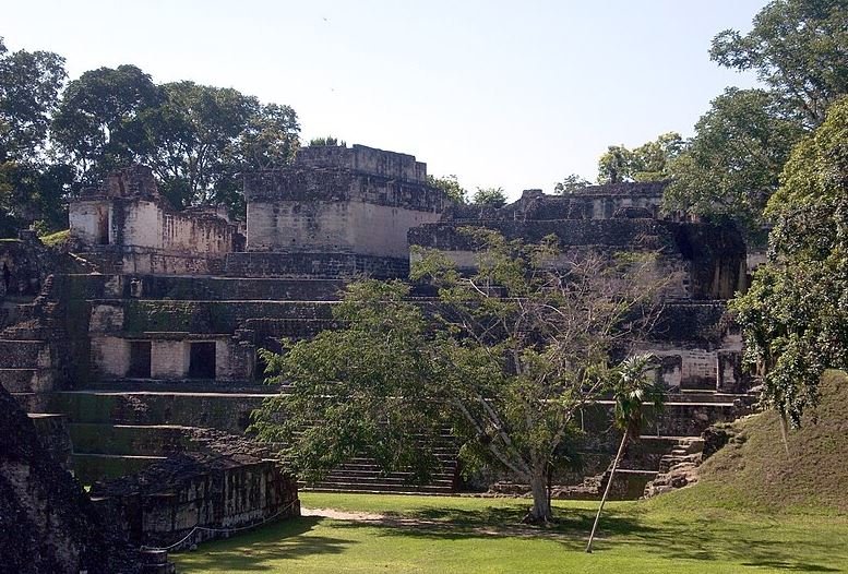
Ancient City of Tikal: History and Major Facts
Tikal, located in northern Guatemala’s Petén Basin, stands as one of the most significant archaeological sites of the ancient Maya civilization. Likely referred to as Yax Mutal in antiquity, this city flourished as a dominant power during the Classic Period (c. 200–900 AD). Today, it is part of Tikal National Park, a UNESCO World Heritage Site. With monumental architecture, complex dynasties, and a vast urban sprawl, Tikal offers unparalleled insight into Maya culture, politics, and daily life.
Origins and Etymology
The modern name “Tikal” likely derives from the Yucatec Maya phrase ti ak’al, meaning “at the waterhole,” referring to the site’s reservoirs. In ancient times, Tikal was known as Yax Mutal, which translates to “First Mutal.” This name distinguished it from Dos Pilas, another city that later adopted the emblem glyph of Mutal.
Geography and Layout
Tikal is located approximately 64 kilometers (40 miles) from Flores, Guatemala, and covers over 16 square kilometers (6.2 square miles) with around 3,000 mapped structures. Elevated limestone ridges provided the foundation for Tikal’s monumental core, while swamps and fertile uplands supported agriculture. The city was strategically positioned to control east-west trade routes across the Yucatán Peninsula.
Tikal’s environment features tropical rainforests with trees such as ceiba (sacred to the Maya) and mahogany. The site’s reservoirs were crucial, as Tikal lacked permanent natural water sources. These reservoirs collected and stored rainwater, vital for the city’s survival during the dry season.

A map of the Mayan region, showing Tikal.
Population
Estimates of Tikal’s population range from 10,000 to as high as 90,000 during its peak in the Late Classic Period. The dense urban core contrasts with surrounding rural areas, forming a vast metropolis that could sustain up to 425,000 people within a 25-kilometer radius.
Early History and Preclassic Period
Tikal’s origins trace back to 1000 BC, with evidence of early agriculture and habitation. By 400 BC, the city had begun constructing major pyramids and platforms. During the Late Preclassic Period, Tikal was influenced by the Izapan culture, with its art and architecture reflecting these Pacific Coast traditions. Despite this, Tikal remained smaller than contemporaries like El Mirador and Nakbe.
Classic Period Rise and Dynastic Rule
The Classic Period (c. 250–900 AD) marked Tikal’s zenith. The city’s dynasty began with Yax Ehb Xook, possibly in the 1st century AD. Tikal’s rulers expanded the city’s influence through warfare and alliances, creating a vast kingdom that dominated the central Maya lowlands.
Collapse of the Maya Civilization in the Terminal Classic Period
Tikal and Teotihuacan
In 378 AD, a significant event transformed Tikal’s political landscape. A Teotihuacan emissary, Siyaj K’ak’ (Fire is Born), arrived and likely overthrew the reigning king, Chak Tok Ich’aak I. This intervention established a new ruling line, with Yax Nuun Ahiin I, a Teotihuacan-linked ruler, ascending the throne. Tikal became a key ally of Teotihuacan, fostering trade and cultural exchanges.
Rivalries and Alliances
Tikal’s prominence led to intense rivalries, particularly with Calakmul, another Maya superpower. This competition shaped the political dynamics of the region, with each city forming extensive alliance networks.
Defeat and Hiatus
In 562 AD, Tikal suffered a catastrophic defeat at the hands of Calakmul and its ally, Caracol. This event initiated the “Tikal Hiatus,” a period marked by a lack of monumental construction and inscriptions. The city’s influence waned, while Calakmul rose to dominate the region.
Late Classic Revival
Tikal’s fortunes reversed in the late 7th century under Jasaw Chan K’awiil I. He defeated Calakmul in 695 AD, marking a resurgence in Tikal’s power. During this period, the city saw extensive architectural activity, including the construction of iconic structures like Temple I and Temple II.
Architecture and Urban Planning
Tikal’s monumental architecture showcases the grandeur of Maya engineering and aesthetics. Structures were primarily built from locally quarried limestone and included:
Temples
- Temple I (Temple of the Great Jaguar): A funerary monument for Jasaw Chan K’awiil I, standing 47 meters tall.
- Temple II (Temple of the Mask): Dedicated to Jasaw’s wife.
- Temple IV: The tallest structure at Tikal, rising 70 meters, commemorating Yik’in Chan K’awiil.
Acropolises
- North Acropolis: A royal burial complex containing numerous stelae and altars.
- Central Acropolis: A palace complex used for administrative purposes.
The Central Acropolis viewed from across the Great Plaza.
Causeways and Reservoirs
Raised causeways (sacbeob) connected the central plaza with outlying areas, facilitating movement during the rainy season. Reservoirs supported the city’s population by storing rainwater, critical in this water-scarce region.
Decline and Abandonment
The Terminal Classic Period (c. 800–1000 AD) brought widespread collapse across the Maya region. Environmental degradation, overpopulation, and prolonged drought likely contributed to Tikal’s decline. By the 10th century, the city was largely abandoned, its population dispersing to other areas.
Rediscovery and Modern Significance
Tikal was rediscovered by local explorers in the 1840s and later studied extensively by archaeologists. Today, it is a UNESCO World Heritage Site and a popular tourist destination, offering a glimpse into the grandeur of ancient Maya civilization.
Frequently Asked Questions
When did Tikal reach its peak, and what was its significance?
Tikal thrived during the Classic Period (c. 200–900 AD), becoming a powerful political, economic, and military center in the Maya region, influencing neighboring cities and engaging with Teotihuacan.
What is the origin of Tikal’s name?
The modern name “Tikal” may derive from the Yucatec Maya phrase ti ak’al (“at the waterhole”) and was applied after its 19th-century rediscovery. The ancient Maya referred to it as “Yax Mutal.”
What are Tikal’s notable architectural features?
Tikal is home to towering pyramids, such as Temple I and Temple IV, expansive palaces, ballcourts, and ceremonial plazas. It includes over 3,000 structures spread across 16 square kilometers.

A closer view of Temple I
How did Tikal sustain its population without natural water sources?
Tikal relied on an advanced system of reservoirs and canals to store rainwater, crucial for its estimated peak population of 50,000–90,000, despite seasonal droughts.
What role did Tikal play in Maya politics and warfare?
Tikal was central in Maya politics, often clashing with rivals like Calakmul and forming alliances or vassal relationships with cities like Uaxactun, Copán, and Dos Pilas.
What is the significance of Teotihuacan’s influence on Tikal?
In 378 AD, Teotihuacan intervened in Tikal, reshaping its politics and culture. Rulers with ties to Teotihuacan established dominance, creating a fusion of Maya and Central Mexican traditions.
What led to Tikal’s decline and abandonment?
By the 9th century, Tikal faced overpopulation, environmental degradation, and political instability, culminating in its abandonment by 950 AD as the Classic Maya civilization collapsed.