Sumerian City of Eridu: History, Accomplishments and Major Facts
Eridu stands as one of the earliest known cities in southern Mesopotamia, embodying significant historical, cultural, and architectural milestones. Situated in present-day Iraq, Eridu’s legacy offers profound insights into the dawn of urban civilization, religious development, and socio-political structures in ancient Mesopotamia.
In the article below, World History Edu explores Eridu’s geographical setting, archaeological significance, historical timeline, architectural achievements, cultural contributions, and eventual decline.
Geographical Location and Environment
Eridu is strategically located on a natural hill within the As Sulaybiyat Depression, a basin measuring approximately 15 miles in length and 20 feet in depth. This basin transforms into a seasonal lake, locally known as a sebkha, from November to April, primarily fed by the discharge of the Wadi Khanega. The city is geographically separated from the Euphrates River by the sandstone ridge called Hazem, while its eastern boundary adjacent to the seasonal lake borders the expansive Hammar Marshes.

Eridu in Ancient Mesopotamia
Situated about 90 miles inland from the Persian Gulf, in the modern-day Dhi Qar Governorate of Iraq, Eridu lies near the contemporary city of Basra. Its proximity to the ancient city of Ur, approximately 15 miles (24 kilometers) south-southwest, positioned Eridu as the southernmost hub among a network of Sumerian cities. This placement facilitated the development of a clustered urban landscape centered around religious temples, fostering a cohesive network of interconnected city-states in close proximity.
Excavation History and Discoveries
The initial excavation of Eridu was undertaken by John George Taylor in 1855, serving as the first significant archaeological endeavor at the site. Taylor’s discovery of inscribed bricks was pivotal in identifying the location as Eridu, laying the groundwork for future explorations.
Subsequent excavations occurred in the early 20th century. R. Campbell Thompson conducted excavations from April 10 to May 8, 1918, followed by H. R. Hall from April 21 to May 8, 1919. Hall’s notable discovery included a piece of manufactured blue glass dated to around 2000 BC, which utilized cobalt for its coloration—a technique that predated its known use in Egypt, indicating advanced technological capabilities in Mesopotamia.
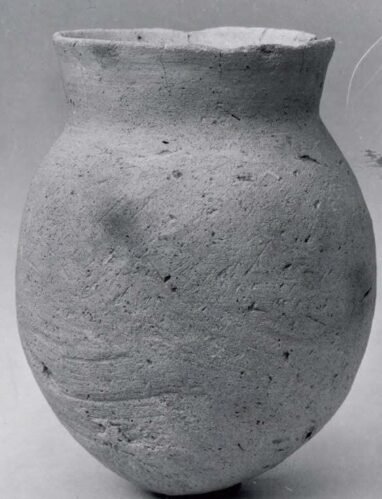
15.24 cm ceramic jar from Tell Abu Shahrain, mid 6th–5th millennium BC, Metropolitan Museum of Art.
Between 1946 and 1949, Fuad Safar and Seton Lloyd led excavations under the Iraqi Directorate General of Antiquities and Heritage. Their work uncovered a diverse array of artifacts, including a Ubaid period terracotta boat model complete with a socket amidship for a mast and holes for stays and rudder, bevel-rimmed bowls, and “lizard type” figurines resembling those found in the Royal Cemetery of Ur. Additionally, they identified a sequence of 17 Ubaid Period temples and a graveyard containing approximately 1,000 mud-brick graves oriented southeast, providing invaluable insights into burial practices and religious structures.
In 1990, A. M. T. Moore revisited Eridu, identifying two previously unnoticed areas of surface pottery kilns, expanding the understanding of the city’s industrial activities. Excavations resumed in 2019 through a collaborative effort involving Italian, French, and Iraqi teams, including the University of Rome La Sapienza and the University of Strasbourg. These recent endeavors focus on producing detailed topographic and photogrammetric maps, primarily targeting the Ubaid period cemetery and its associated residential areas, thereby enhancing the precision and scope of archaeological investigations.
Architectural Achievements

Painted pottery vessel from Eridu, Tell Abu Shahrain, Iraq, 3500-2800 BCE, Baghdad Museum.
The architectural heart of Eridu was the E-abzu temple, dedicated to the god Enki (Ea), the deity of deep waters, wisdom, and magic. Known as the House of the Aquifer or House of the Waters, the temple was central to the city’s religious and administrative life. The temple complex evolved significantly over time, beginning as a simple mud-brick square with a niche during the early Ubaid period and expanding into a tripartite structure by Level VI.
In neighboring Ur, temples dedicated to Ishtar of Eridu were built by Ur-Baba of Lagash and Ur-Nammu of the Ur III dynasty, including a reconstructed Ishtar temple.
During the Ur III period, Ur-Nammu constructed a ziggurat over the remnants of earlier temples, transforming the religious landscape of Eridu. This monumental structure, spanning 300 square meters, served as a base for the ziggurat, symbolizing the city’s enduring architectural prowess and its commitment to religious devotion.
Mound 2, located one kilometer north of Abū Šahrain, houses an Early Dynastic palace, indicative of centralized governance and socio-political organization. The palace, alongside remnants of city walls constructed with plano-convex bricks, underscores Eridu’s architectural sophistication and its role as a political center within the Sumerian city-state framework.
The discovery of a Ubaid period terracotta boat model, bevel-rimmed bowls, and figurines highlights Eridu’s artistic and technological advancements. These artifacts reflect the city’s maritime activities, daily life, and religious practices, showcasing the intricate craftsmanship and cultural expressions of its inhabitants.
Historical Timeline and Inhabitance
Eridu was founded around 5400 BC during the early Ubaid period, establishing it as one of the earliest urban settlements in Mesopotamia. Initially situated near the Persian Gulf close to the Euphrates’ mouth, the city’s strategic location facilitated agricultural development and trade, contributing to its growth and prominence.
Eridu remained continuously inhabited through multiple historical epochs, including the Early Dynastic, Akkadian Empire, Isin-Larsa, Old Babylonian, Kassite, and Neo-Babylonian periods. Each era left its imprint on the city’s architecture, artifacts, and socio-political structures, reflecting the dynamic nature of Mesopotamian civilizations.
- Early Dynastic III Period: Marked by the construction of monumental palaces and extensive pottery production, indicating heightened political and cultural activities.
- Akkadian Empire: Although potential interruptions in occupation occurred, Eridu continued to serve as a significant religious and cultural center.
- Uruk Period: Characterized by the presence of non-secular buildings and extensive pottery, demonstrating Eridu’s integration into the broader Uruk cultural sphere.
- Isin-Larsa and Old Babylonian Periods: Eridu saw continued construction projects, including temple renovations and canal restorations, underscoring its enduring religious significance.
- Kassite and Second Sealand Dynasties: Inscriptions and construction efforts during these periods indicate Eridu’s continued, albeit primarily cultic, importance.
- Neo-Assyrian and Neo-Babylonian Empires: Eridu maintained its religious stature, with rulers like Sargon II and Nebuchadnezzar II undertaking restoration projects, preserving its legacy as a sacred site.
Abandonment
Eridu was eventually abandoned around 600 BC during the Neo-Babylonian Empire. Archaeological evidence suggests that increasing soil salinity from continuous irrigation practices likely led to agricultural decline, economic stagnation, and the eventual desertion of the city. This abandonment marked the end of Eridu’s millennia-long habitation, transitioning it from a thriving urban center to a primarily cultic site.
Archaeological Controversies
In March 2006, Giovanni Pettinato and S. Chiod announced the discovery of 500 Early Dynastic cuneiform tablets at Eridu, purportedly part of a historical and literary library dating from 2600 to 2100 BC. This claim generated significant interest and scrutiny within the archaeological community.
Eridu’s strategic location, intricate canal systems, and monumental architecture reflect the sophisticated societal organization of its inhabitants.
However, subsequent investigations by Iraq’s State Board of Antiquities and Heritage debunked the claim, revealing that no tablets were found. Instead, only stamped bricks from Eridu and nearby sites like Ur were discovered. It was clarified that the alleged tablets were, in fact, 70 inscribed bricks used in constructing the modern dig-house, originally sourced from Leonard Woolley’s expedition at Ur and repurposed in 1962 for restoration efforts. This controversy highlighted the importance of meticulous verification in archaeological claims.
Cultural and Religious Significance

Eridu’s enduring religious significance, embodied in the E-abzu temple and its association with deities like Enki, underscores the central role of spirituality in shaping Eridu’s identity and legacy. Image: The Adda Seal, an ancient Akkadian cylinder seal showing (from left to right) Inanna, Utu, Enki, and Isimud (circa 2300 BC)
Enki and the E-abzu Temple
The E-abzu temple, dedicated to Enki (Ea), was not only the architectural centerpiece of Eridu but also the spiritual heart of the city. Enki, the god of deep waters, wisdom, and magic, was a central deity in Sumerian mythology. The temple complex served as a hub for religious ceremonies, administrative functions, and scholarly activities, reflecting the intertwined nature of religion and governance in ancient Mesopotamia.
A significant religious quarter in Babylon named Eridu contained important temples like the Esagila and Annunitum.
Enki’s consort, Ninhursag, had a nearby temple at Ubaid, indicating a network of religious sites dedicated to major deities. The repeated renovations and expansions of the E-abzu temple by Sumerian kings such as Elili of Ur, Ur-Nammu, Shulgi, Amar-Sin of Ur-III, and Nur-Adad of Larsa underscore the temple’s enduring religious and political importance.
Religious Network and Urban Clusters
Eridu’s position as the southernmost hub among Sumerian cities facilitated the development of a network of urban centers centered around religious temples. This clustering fostered cultural exchange, economic interactions, and political alliances, contributing to the cohesive development of Sumerian civilization.
Artistic and Technological Contributions
Eridu’s archaeological finds, including terracotta models, inscribed bricks, and pottery, reflect the city’s artistic and technological advancements. The discovery of blue glass utilizing cobalt predates similar techniques in Egypt, showcasing Eridu’s role in pioneering material technologies.
Mythology and Literary References
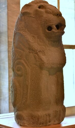
Ancient statue of a standing lion from Eridu, Iraq, circa mid-3rd millennium BC.
In various versions of the Sumerian King List, Eridu is depicted as the first city where kingship was established before a great flood. The list names two early rulers of Eridu, Alulim and Alalngar, who are said to have reigned for extraordinarily long periods—28,800 and 36,000 years, respectively. This portrayal emphasizes Eridu’s foundational role in the mythological and political landscape of Sumer.
Eridu is linked to the star Canopus, known as MUL.NUNKI in Babylonian astronomy, symbolizing the city in star catalogs and early astronomical texts. Due to the Earth’s axial precession, Canopus was observable from Eridu approximately 6,000 years ago, marking its prominence in celestial observations and reinforcing Eridu’s cultural and astronomical significance.
Mythological narratives, such as the flood myth tablet from Ur, elaborate on Eridu’s divine selection and its inhabitants’ obedience to divine commands. Eridu is portrayed as the home of Enki and the Abzu temple, central to the city’s religious identity. Adapa, a figure from Eridu, is depicted as an early culture hero who either served as a postdiluvian ruler or as Alulim’s vizier, contributing significantly to the city’s civilization and cultural development.
The decline of Eridu is reflected in Sumerian literary genres known as City Laments. The “Lament for Eridu” details the city’s downfall, describing its abandonment and ruin with divine and human inhabitants expressing sorrow over its demise. These laments suggest that Eridu’s decline was perceived as a consequence of losing favor with the gods, a recurring theme in Mesopotamian literature.
Decline and Abandonment
Eridu’s long history of habitation came to an end around 600 BC during the Neo-Babylonian Empire. Archaeological evidence points to increased soil salinity resulting from continuous irrigation as a primary factor leading to agricultural decline. This environmental degradation likely caused economic stagnation, reducing the city’s viability and leading to its eventual abandonment.
The city’s decline is further underscored by literary accounts, such as the “Lament for Eridu,” which portrays the city’s ruin as a divine punishment for losing favor with the gods. This narrative aligns with broader Mesopotamian beliefs attributing urban decline to spiritual and divine causes.
Major Accomplishments and Contributions

Traditionally regarded as the earliest city in southern Mesopotamia according to the Sumerian King List, Eridu was situated 15 miles (24 kilometers) south-southwest of the ancient site of Ur. Image: Ruins of a ziggurat at Eridu
Eridu’s establishment as one of the earliest urban centers in Mesopotamia highlights its role in the development of city planning and centralized governance. The construction of monumental temples, palaces, and city walls reflects sophisticated urban organization and architectural innovation.
As a primary religious center dedicated to Enki, Eridu played a pivotal role in shaping Sumerian religious practices and mythology. The E-abzu temple served as a model for subsequent religious structures, influencing the architectural and spiritual landscape of Mesopotamia.
The discovery of blue glass utilizing cobalt predates similar technologies in other ancient civilizations, demonstrating Eridu’s contributions to material science and craftsmanship. Additionally, the construction techniques employed in Eridu’s buildings, such as the use of plano-convex bricks, showcase advanced engineering skills.
Eridu served as the southernmost center among a network of Sumerian cities developing around religious temples.
Eridu’s prominence in Sumerian mythology and literary texts, including the King List and flood myths, underscores its foundational role in shaping the cultural and spiritual narratives of Mesopotamia. Figures like Adapa and rulers such as Alulim and Alalngar are central to these narratives, reinforcing Eridu’s mythological significance.
The extensive archaeological findings from Eridu, including terracotta models, inscribed bricks, pottery, and figurines, provide invaluable insights into early Mesopotamian society. These artifacts reveal details about daily life, religious practices, technological advancements, and socio-political structures, contributing significantly to the broader understanding of ancient civilizations.
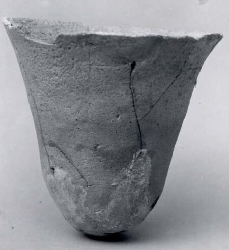
8.56 cm ceramic cup from Tell Abu Shahrain, mid 6th–5th millennium BC, Metropolitan Museum.
Conclusion
Eridu’s legacy as one of the earliest urban centers in southern Mesopotamia is cemented through its rich archaeological record, architectural achievements, and profound cultural and religious significance. From its strategic geographical location and sophisticated urban planning to its pivotal role in Sumerian mythology and religious practices, Eridu offers a comprehensive window into the dawn of civilization. Despite its eventual decline, the city’s enduring influence is evident in the continued study and preservation efforts undertaken by international archaeological teams.
Frequently Asked Questions

Ceramic bowl discovered in Grave 134 of the Ubaid Cemetery at Eridu.
Where is Eridu located geographically?
Eridu is situated on a natural hill within the As Sulaybiyat Depression, a basin approximately 15 miles long and 20 feet deep, in present-day Dhi Qar Governorate, Iraq. It lies about 90 miles inland from the Persian Gulf near the modern city of Basra and approximately 24 kilometers south-southwest of the ancient city of Ur.
What natural features influence the environment of Eridu?
Eridu is separated from the Euphrates River by the sandstone ridge called Hazem. The As Sulaybiyat Depression becomes a seasonal lake, or sebkha, from November to April, fed by the Wadi Khanega. Additionally, the eastern edge adjacent to the seasonal lake borders the Hammar Marshes.
How was Eridu connected to the Euphrates River during the 3rd Millennium BC?
During the 3rd Millennium BC, Eridu was connected to the Euphrates River by the Id-edin-Eriduga canal, meaning “the canal of the Eridug plain.” Over time, the Euphrates shifted its course, and the canal’s path is now marked by several low tells containing surface pottery from the 2nd Millennium BC and later burials.
How many mounds make up the archaeological site of Eridu, and what is their significance?
The archaeological site of Eridu comprises eight distinct mounds, each with unique features and historical significance. These mounds contain various structures and artifacts from different periods, including temples, palaces, city walls, pottery, and layers from multiple historical eras such as the Ubaid, Early Dynastic, Isin-Larsa, Kassite, Neo-Babylonian, and Achaemenid periods.
Who conducted the initial excavations of Eridu, and what key discovery was made?
The initial excavation of Eridu was conducted by British diplomat John George Taylor in 1855. He identified the site through inscribed bricks, which confirmed its identification as Eridu.
What significant artifact did H. R. Hall discover during his excavation, and why is it noteworthy?
In 1919, English Egyptologist H. R. Hall discovered a piece of manufactured blue glass dated to around 2000 BC. This artifact is noteworthy because it utilized cobalt for its blue coloration, a technique that preceded its known use in Egypt.
What were the major findings of the excavations led by Fuad Safar and Seton Lloyd between 1946 and 1949?
Archeologists Fuad Safar and Seton Lloyd uncovered a Ubaid period terracotta boat model with features such as a socket for a mast and holes for stays and rudder. They also found bevel-rimmed bowls, “lizard type” figurines similar to those from the Royal Cemetery of Ur, a sequence of 17 Ubaid Period temples, and a graveyard containing approximately 1,000 mud-brick graves oriented southeast.
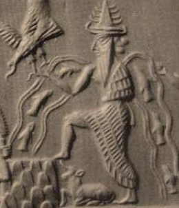
Enkidu’s principal deities were Enki (Ea) and his consort Damkina, with Enki credited as the founder. His temple, E-Abzu, constructed with gold and lapis lazuli, stood by the Euphrates river, its foundation on the nether-sea filled in, symbolizing the Abzu aquifer believed to be the origin of all life, and was alternatively called Esira in Sumerian hymns. Image: Enki detailed on Adda Seal, an Akkadian cylinder seal from approximately 2,300 BC.
What archaeological controversy arose in March 2006 regarding Eridu, and what was the outcome?
In March 2006, researchers Giovanni Pettinato and S. Chiod claimed to have discovered 500 Early Dynastic cuneiform tablets at Eridu. However, investigations by Iraq’s State Board of Antiquities and Heritage found no tablets, only stamped bricks from Eridu and nearby sites. It was later clarified that the supposed tablets were actually 70 inscribed bricks used in constructing the modern dig-house, originally sourced from Leonard Woolley’s expedition at Ur.
What is the architectural significance of the E-abzu temple in Eridu?
The E-abzu temple, dedicated to the god Enki (Ea), was the urban core of Eridu. Known as the House of the Aquifer or House of the Waters, it was central to the city’s religious life. During the Ur III period, Ur-Nammu constructed a ziggurat over the remnants of earlier temples. The temple was repeatedly renovated and expanded by several Sumerian kings, highlighting its enduring religious and architectural significance.
How long was Eridu inhabited, and what led to its eventual abandonment?
Eridu was inhabited from its foundation around 5400 BC during the early Ubaid period until its abandonment around 600 BC during the Neo-Babylonian Empire. Archaeological evidence suggests that increased soil salinity from continuous irrigation likely caused stagnation and contributed to the city’s eventual abandonment.

Sumerian King List
What role does Eridu play in Sumerian mythology and the Sumerian King List?
In Sumerian mythology and the Sumerian King List, Eridu is depicted as the first city where kingship was established before a great flood. The list names two early rulers of Eridu, Alulim and Alalngar, who reigned for extraordinarily long periods. Eridu is also associated with the star Canopus (MUL.NUNKI) in Babylonian astronomy and is portrayed as the divine selection for kingship and religious authority.
What recent archaeological efforts have been undertaken at Eridu, and what are their focuses?
Excavations resumed in 2019 through a collaborative effort involving Italian, French, and Iraqi teams, including the University of Rome La Sapienza and the University of Strasbourg. These recent endeavors focus on producing detailed topographic and photogrammetric maps, primarily targeting the Ubaid period cemetery and its associated residential areas. Additionally, in 1990, A. M. T. Moore identified two previously unnoticed areas of surface pottery kilns.
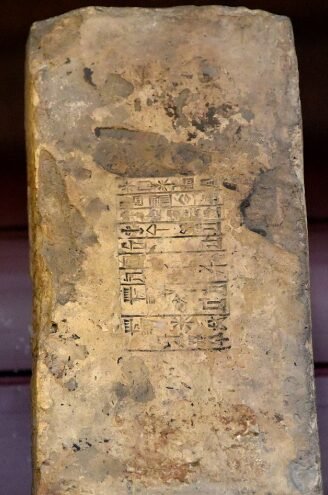
Fired clay brick stamped with Amar-Sin of Ur III, from Eridu, housed in British Museum.